|
|
| Pages: 1 2 3 4 5 6 7 8 9 10 |
|
Pages: 11 12 13 Maps: 1 2 3 |
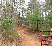 Remnants of the old road. Remnants of the old road. |
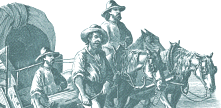
To
follow their approximate path from present day Philpott go east across the
railroad tracks and turn sharply right. You will climb a steep hill and
then ride for several miles along a ridge. This is a pleasant stretch of
road - few houses and little traffic. Looking off to the south you will
again catch glimpses of Pilot Mountain and you may see evidence of the old
Morgan Bryant road off through the woods. Now you must watch for the watertank
to turn right. Turn right again on a street named 'Sunset.' Immediately
you feel like you are returning to civilization and very soon the road drops
sharply down into Bassett. |
 |
|
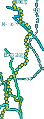
Map Detail: Smith River • Horsepasture Creek • North Mayo River • South Mayo River • |
||
Read More About Henry County, VA ©Copyright 2000-2026 . e-dzine.com |
||