 |
|
| Pages: 1 2 3 4 5 6 7 8 9 10 |
|
Pages: 11 12 13 Maps: 1 2 3 |
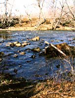
 Possible Smith River ford Possible Smith River ford |
It is probably impossible
to determine exactly where the Brothers actually forded the Smith. The old
Fry-Jefferson map of 1751 shows the crossing at the intersection of the
Smith River and Blackberry Creek. Years of flooding and soil deposits have
erased all traces. Drive south along the river from Bassett to Stanleytown; turn west over the bridge just past the last Stanley Furniture plant. Once over the river turn left onto state route 57A. Stop at the entrance to Bassett High School and look at the very old home across the street. This is Hordsville and it sits on a knoll near the river. It was occupied originally by the Hairston family. Somewhere near Hordsville stood Hickey's Ordinary or store. Mr. Hickey was very well known. In fact, present day route 57 from this spot to a point northeast of Chatham, Virginia was originally known as "Hickey's Road". Just after the Brothers crossed the river ... |
 |
| "Mr.
Hikki who lives half a mile from here and who has a store came to meet us
and was very friendly". And so if you continue on a little ways past Hordsville and turn left towards Whitby Acres you will soon spot the scene pictured above. Looks like a good place to cross doesn't it? The Great Road |
||
|
Map Detail: Smith River • Horsepasture Creek • North Mayo River • South Mayo River • |
||
Read More About Henry County, VA ©Copyright 2000-2026 . e-dzine.com |
||