|
|
| Pages: 1 2 3 4 5 6 7 8 9 10 |
|
Pages: 11 12 13 Maps: 1 2 3 |
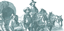
 "We
went on four miles, and stopped for noon at Adam Loving's plantation, where
we bought ten bushels of corn, and the people
were very friendly." "We
went on four miles, and stopped for noon at Adam Loving's plantation, where
we bought ten bushels of corn, and the people
were very friendly."
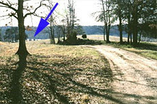
After leaving the airport road turn west on Route 58. Turn left on the Old Well Church Road. This road dead-ends at the Mayo and all along it you can see vestiges of the old road cut. After several miles turn right to a cattle gate across a dirt driveway. Stop and look over the gate - you will see the view pictured at right. This is a portion of the actual road that is still used. Near the point of the blue arrow stood Adam Loving's house and at the base of the trees in the distance runs the North Mayo River. As recently as 40 years ago a two-story house still stood on or near the site of Loving's home. At that time the property was owned by Ev Adkins - but sadly no one took pictures of the house. "The man showed us the ford through the first branch of the Meho River ... but [it] has such steep banks that it took us two hours to cross ... Three miles beyond we reached the main branch of the Meho. The approach was fairly easy but the other side much worse, and we worked into the night before we could make the bank passable ... We spent the night there, and as we had little wood we all gathered around one fire, sleeping for the last time on Virginian soil." Carolina |
 |
|
|
Map Detail: Smith River • Horsepasture Creek • North Mayo River • South Mayo River • |
||
Read More About Henry County, VA ©Copyright 2000-2026 . e-dzine.com |
||