|
|
| Pages: 1 2 3 4 5 6 7 8 9 10 |
|
Pages: 11 12 13 Maps: 1 2 3 |
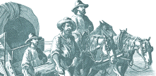
| What does this have to do with a road in Henry County? Back in 1753 there
were very few roads but there were paths. The native buffalo and other large animals created trails through the forest long before Europeans arrives. These animal trails were used by Indians and then were widened
by European immigrants bringing wagons and pushing the frontier westward. As more people
settled along the road residents assumed responsibility for keeping it
passable - smoothing out ruts, cutting back brush. When the Moravian 'single brothers'
left Bethlehem, Pennsylvania and headed south towards North Carolina they
followed one of these paths down the Shenandoah Valley. When they reached
Roanoke the road branched - one route to the southeast - across the Blackwater
River to Boone's Mill, west of present day Rocky Mount to Callaway and
Ferrum and on to Henry. This branch was known as the Morgan Bryant (Bryan)
Road after the man who had widened the old path enough to drive a cart
over it on his way to settle the Yadkin Valley in 1740.
|
 |
|
|
Map Detail: Smith River • Horsepasture Creek • North Mayo River • South Mayo River • |
||
Read More About Henry County, VA ©Copyright 2000-2026 . e-dzine.com |
||